Austin Gap with Ravens Nest, Staircase Caves, and Skyview Rock Shelter

Overview. This is a spectacular hike and leads to arguably the most interesting geological formations on Pine Mountain’s 120+ mile ridgeline. At the top, you’ll enjoy massive views east and south across Virginia, a pair of small caves, and an arch complex with a skylight that is absolutely stunning. BUT, you’re gonna have to work for it - see the notes below.
Route Type | Out and Back
Total Distance | 5.64 miles
Elevation Gain | 1,824 feet
Overall Difficulty | Strenuous
*this is a tough hike with route finding challenges; do not hike this unless you are in shape, carry the 10 essentials, are experienced in off trail navigation, and pack sufficient hydration for the effort
GPS Waypoints
Austin Gap Trailhead | 37.165307, -82.585931
Loop Fork | 37.167608, -82.596967
Sometimes Water | 37.161669, -82.607764
Ravens Nest | 37.169694, -82.613897
Staircase Caves | 37.1695278,-82.6129722
Austin Gap | 37.1699861,-82.6118278
Turn to Skyview | 37.170317, -82.610707
Skyview Rock Shelter | 37.169903, -82.609641
Survey Tape Waypoint | 37.169283, -82.611417
Zoomed PMSST Infoboard Map
Birch Knob Section PMSST Map
Parking. Limited roadside parking is available for two or three vehicles. Additional parking appears to be available outside the Austin Family Cemetery. Do not block the gates.
Trail Navigation. I intended to hike this as a loop, but the fire recovery zone at Austin Gap turned it into an out and back. The burn zone explains the massive difference in wear patterns at the initial fork after topping out on Big Ridge. Note that this is or was an active ATV trail network, so stay on trail by following the blue blazes and pink survey tape. This trail could use more blazes and a re-route around the burn section. But, here are the nav steps in simplest form:
Locate the unmarked trailhead across from the cemetery that has a couple large rocks at its base
Hike uphill on the old forest road and top out on Big Ridge
Turn left at the fork and head southwest
Continue on the flat ridgeline, passing a small burn area
Reach the next unmarked junction and follow the survey tape to the right (northwest) and bend left around the ‘corner’
Shortly reach a steep descent to a sometimes water source and crossover
Hike uphill following the doubletrack trail and occasional pink survey tape
From here, do your best to navigate to Ravens Nest taking the least obstructed path possible; I came up directly beneath it before returning on the official trail that was more problematic than my initial bushwhacking route
Once up to Ravens Nest, take a break and enjoy the views
Drop down to the east side of Ravens Nest using Pine Mountain State Scenic Trail/Great Eastern Trail (yellow reflective blazes) and pass the Ravens Nest sign
Continue on trail and take the very, very short spur to Staircase Caves
Retrace to the main trail and continue northeasterly to Austin Gap and enjoy the views provided by the forest fire; you can see all the way to High Knob in Norton, Virginia…and beyond
Continue on trail and reach the Skyview Rockshelter sign; descend here with a southeast heading before winding your way east and then dropping down south. Use the waypoint above and do your best to get through the soup - it’s worth the trouble
Take a nice, long look around you inside of Skyview. It has a skylight, a small arch at its base, the big arch that you’re inside of, a small arch on the west wall, and another arch in the recess north. In other words, there’s a lot to see in here.
After enjoying the scene, retrace your steps or blaze a new path back to the main trail and turn left (southwest)
You can take the official trail that is marked with tape just past the Austin Gap sign or retrace if you came up Ravens Nest
Retrace the rest of the way down to the trailhead
You will get ‘lost’ at least temporarily; keep working your way back to the defined doubletrack
HIKER NOTE - Ravens Nest. This wasn’t listed on any of the maps found on the web, but was noted on the trailhead map of the Birch Knob Section of the Pine Mountain State Scenic Trail. The rock outcropping is relatively small, but provides a stellar view. It is marked with a sign at its base on the east side and has metal steps made with bars and overlayed metal sheets.
HIKER NOTE - Route Finding for Skyview Rock Shelter. I had to poke and prod a little bit to find this through all the thorns and fallen tree carcasses. There is some semblence of a trail that likely is more discernable outside the growing season, but generally speaking, try to approach from the east of the waypoint to reach the more accessible side of the rock shelter. Also take care with your steps if you wind up on top of the rock shelter - there is a skylight that would make for a disastrous fall.
HIKER NOTE - Alternate Route. Austin Gap and all the goodies can be accessed from the Pound Gap Trailhead on the northside of US-23. I have not hiked this route yet, but believe it’s much easier with less elevation gain. Park in the gravel lot next to the very nice gas station, cross US-23 and walk east. Walk up Apostolic Road and go past the church to pick-up the trail on the utility road that leads to a communications tower. Here is a waypoint to get you started | 37.157255, -82.630183
CAUTION - No Reliable Water. There was one water source that was somewhat stagnant in the depression between Big Ridge and Austin Gap. During wet periods, this is likely a decent enough water source for filtering. During dry periods, it is not dependable. Load up with water and electrolytes before heading up the mountain.
CAUTION - Hiking in a Fire Recovery Zone. There was a fire on the southeast side of the ridge at Austin Gap. As a result, the entire tree canopy was lost and replaced with dense vegetation and loads of thorns. This completely obscures the route to Skyview Rock Shelter and the top portion of the Austin Gap Loop Trail. This is an official trail in Jefferson National Forest for now, but it may be abandoned or truncated in the future. Regardless, hiking through the fire recovery zone is arduous, so plan your time accordingly. Long pants are best unless it is prohibitively hot.
CAUTION - Deadly Drops. Long falls from high places are the #1 non-health related cause of death for hikers in Kentucky. Keep your distance from the edges of cliffs to avoid a deadly fall. Young children should be kept close.
CAUTION - Poisonous Snakes. Copperheads and timber rattlesnakes can be found in the area. Should you encounter one, stop and slowly back away. Always give venomous snakes a wide berth. Know Before You Go => University of Kentucky Venomous Snake Guide
CAUTION - Black Bears. Ursus Americanus - a.k.a. the American black bear is growing in population throughout much of Kentucky. Know Before You Go => US Forest Service Black Bear Safety Tips

Austin Family Cemetery Gate

Unmarked Austin Gap Trailhead

Gorgeous Forest Walking

Go Left at the Fork

Water Source on Austin Gap Trail between Big Ridge and Pine Mountain

Follow the Blue Blazes Until They and the Defined Trail Run Out

Metal Stairs at the Base of Raven's Nest

View of Pine Mountain's Ridgeline Northeast

View South to High Knob in Norton, Virginia
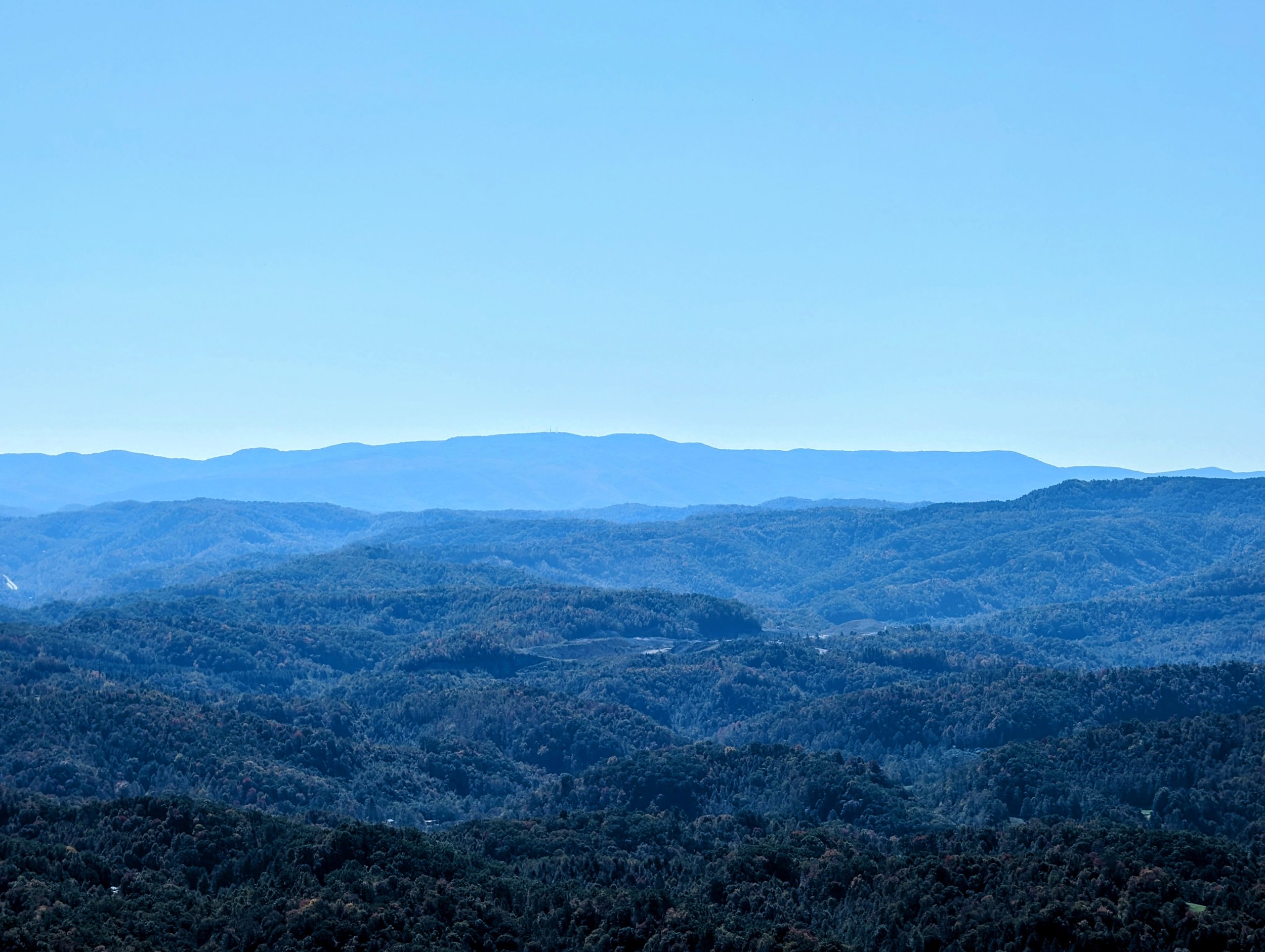
Zoomed View Out to High Knob on Stone Mountain

Ravens Nest Sign on Pine Mountain State Scenic Trail

Skull-ish Rock

Staircase Caves Trail Junction

Ghostly Teddy Bear in Staircase Caves on Friday the 13th
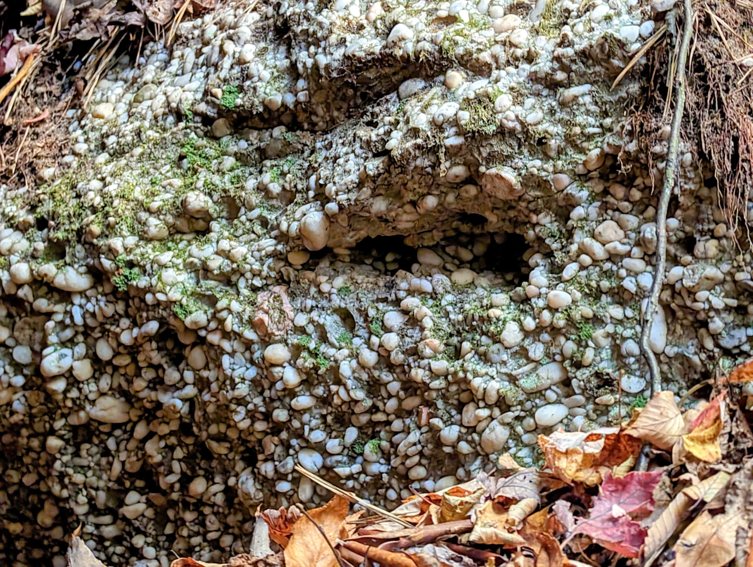
Conglomerate Rock Layer

Austin Gap Trail Sign, Pine Mountain State Scenic Trail/Great Eastern Trail

View Over Austin Gap Recovery Zone to High Knob, Virginia

Sky View Rock Shelter Trail Sign
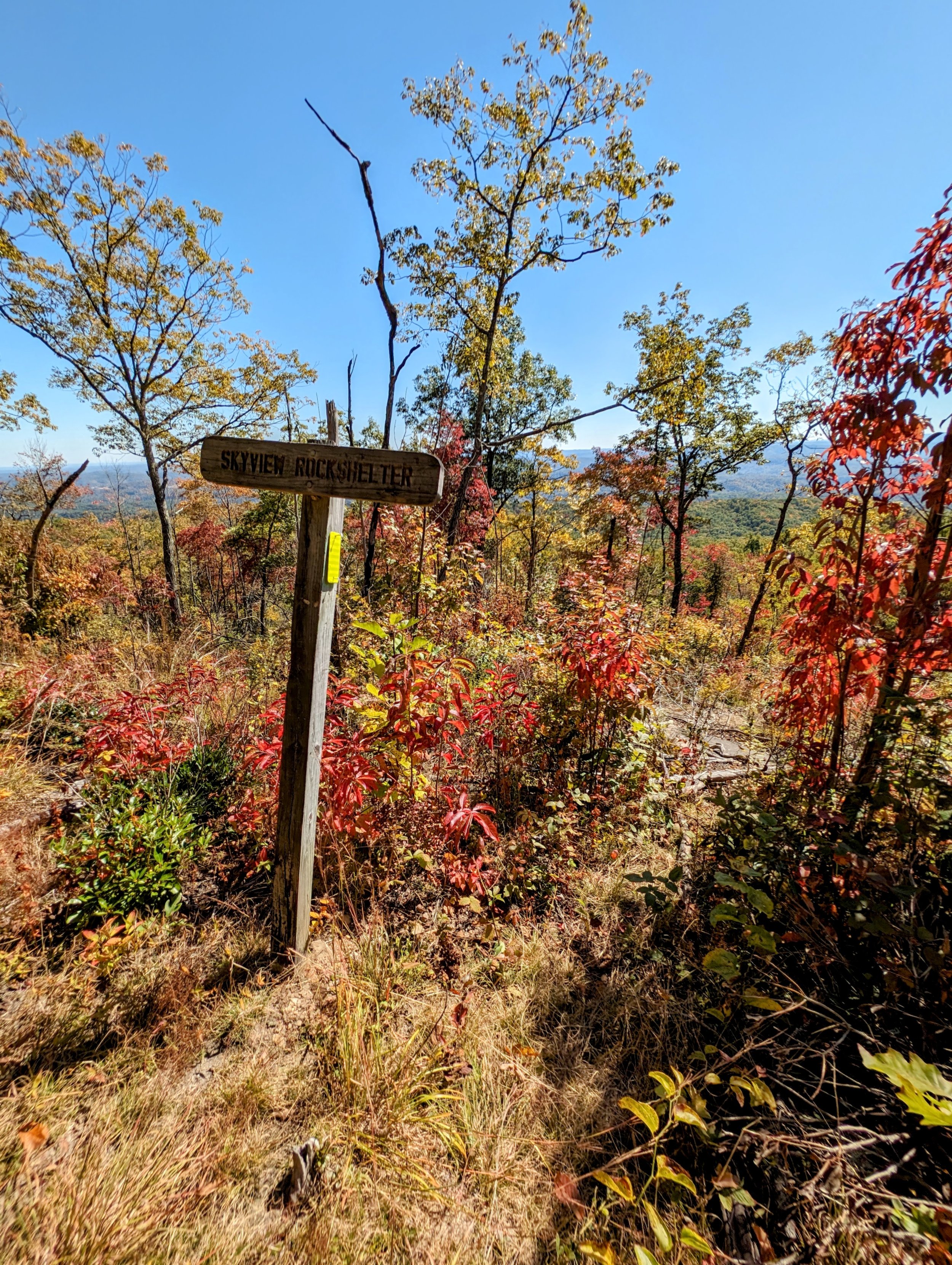
Sky View Rock Shelter Trail Spur - It’s route finding from here through the burn zone down to the rock shelter. I wish I’d have brought clippers and a small handsaw to better reveal the trail for the next hiker, so I’ll return in wintertime using the out and back from US-23 to do exactly that.

Arch at the Foot of Sky View Rock Shelter

Skyview Rock Shelter from the Foot of the Formation

Looking Up through the Skylight

Another Arch in the Wall of Skyview Rock Shelter
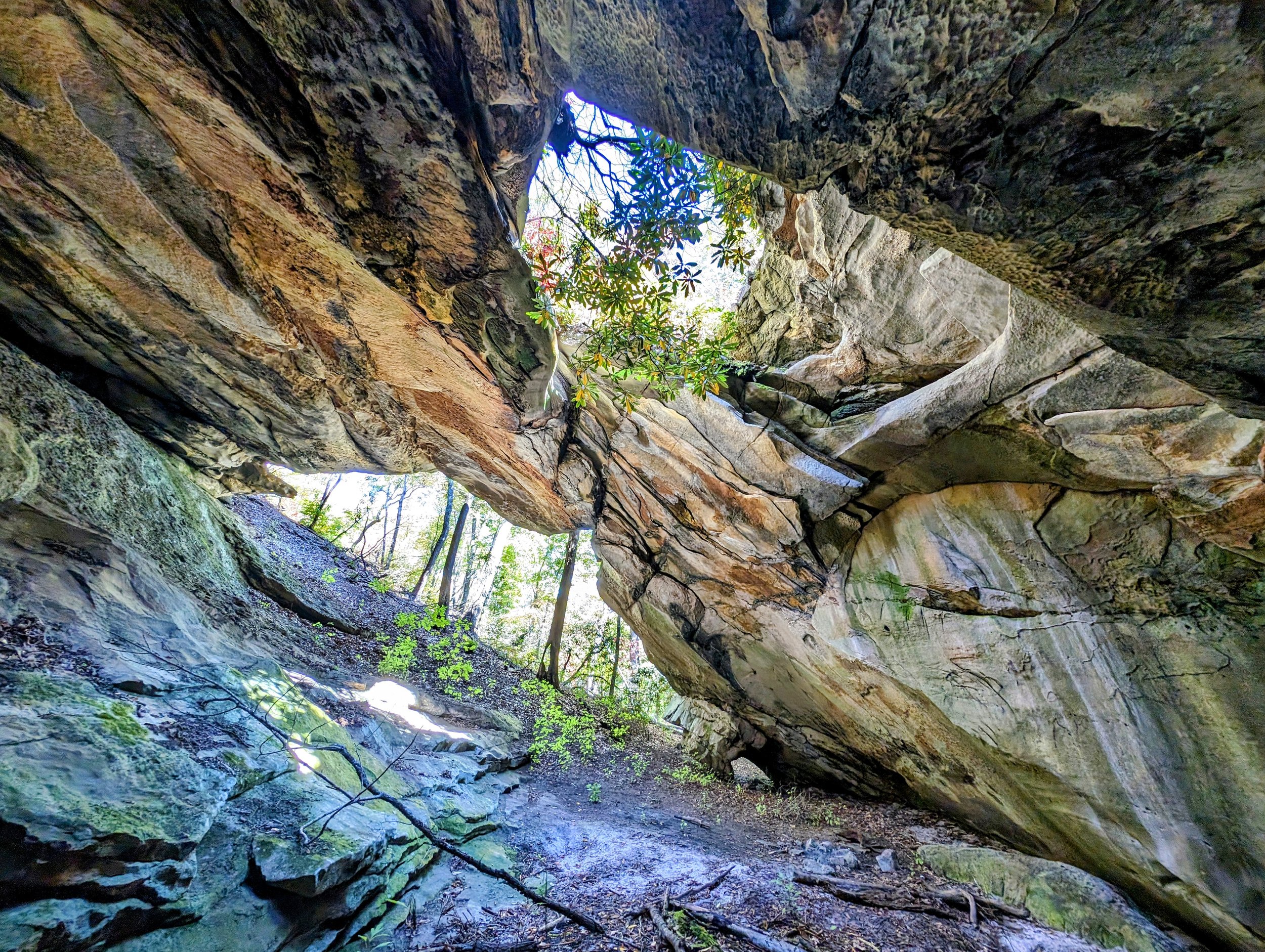
An Incredible Scene at Skyview Rock Shelter

A Final Look at Skyview Rock Shelter

Austin Gap Trail-Pine Mountain State Scenic Trail Junction - Follow the pink survey tape through the recovery zone to descend and eventually reach blue blazed trail back to the Austin Gap Trailhead